Wednesday 27 October 2021

Classic Descents In The Cleveland Hills. Episode Two - Roxby Moor

 Classic Descents In The Cleveland Hills.


This series hopes to show our best-loved tracks on the moors, usually using the GoPro Hero 9 Hypersmooth mode because nobody wants to sit through fifteen minutes of chest cam footage, however magnificent the surroundings. Being someone who is against the whole best of, top ten mentality, especially when applied to unquantifiable entities, they are in no particular order, each one is someone’s favourite.


Episode Two.


Roxby Moor


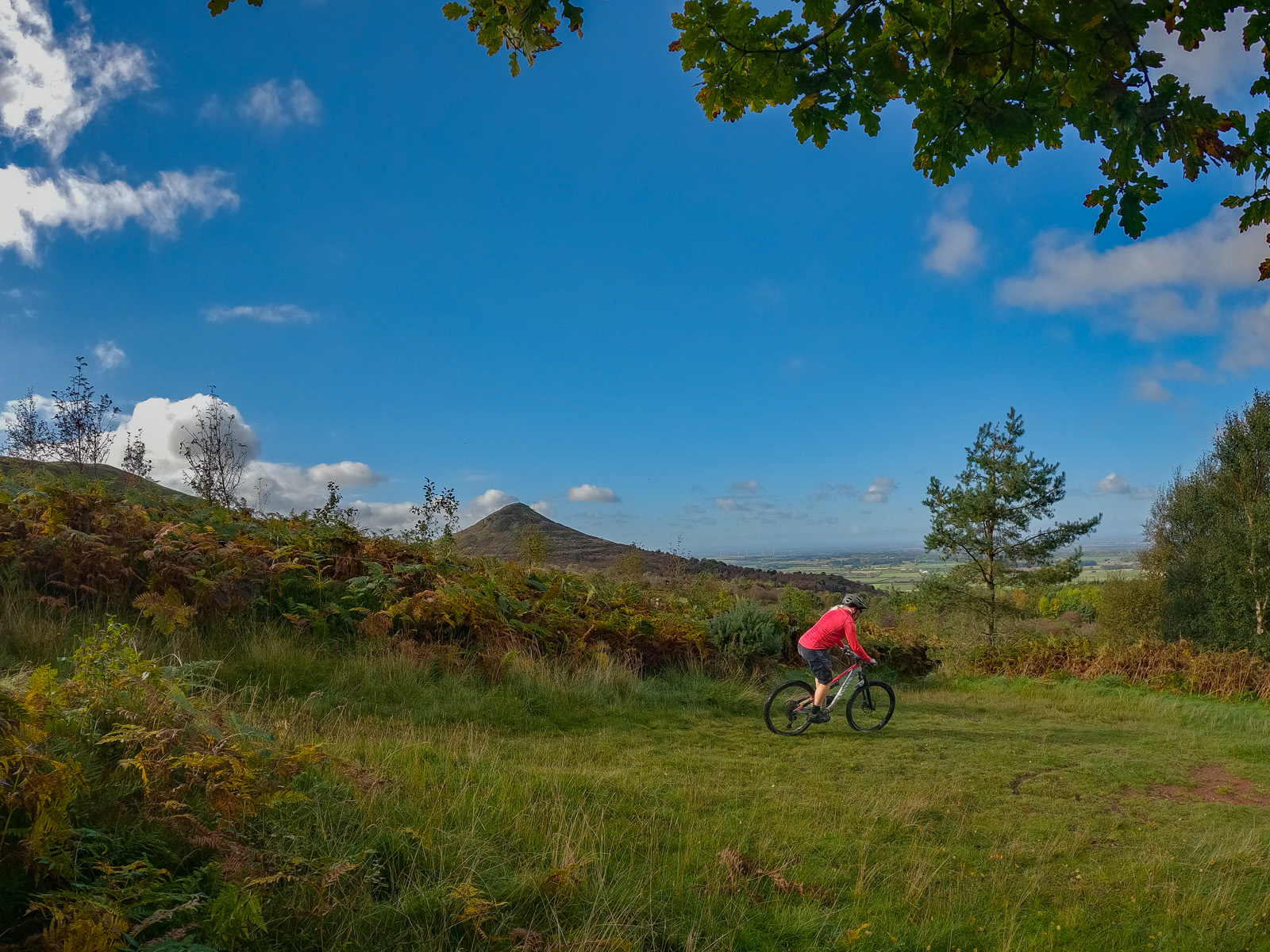
Like Accelerator at Hamsterley Forest, the Roxby Moor bridleway doesn’t appear to be a descent at all until you realise how fast you are going. Usually when a pedal clips the side of a rut and jettisons the unfortunate rider into the heather. It is not even a classic singletrack but a double track, which opens up some dual slalom possibilities for those so inclined. From Danby Beacon, a broad, stoney track, Lealholm Rigg, heads east, about half a mile down, a bridleway branches off to the left, the track barriered to vehicles by a chain is the Roxby Moor track, although I think it is known as Brown Rigg on Strava but we’ve always called it the Roxby Moor track. The bridleway drops a couple of hundred feet in just over a mile, with a fine view across the heather to Scaling reservoir, glinting like lapis lazuli in the sunshine - if there is any. The downhill ends at a junction of tracks and bridleways, we usually go straight on arriving at the minor road leading to High Tranmire Farm. From here there are numerous options to continue your ride.


About Classic Descents In The Cleveland Hills.


They might not all be in the Cleveland Hills, possibly not even descents and whether they are classics or not is purely subjective but we enjoy them and I’m not one to spoil an alliterative title with facts. The Cleveland Hills form the North West edge of the North York Moors and it is the area where most of our riding takes place, predominantly cross-country; purple moors under big skies, criss-crossed by a network of sandy tracks which link up wholly natural descents, loose and ungroomed, a world away from risk assessments and construction design management. No marker posts or direction arrows, get a map or some local knowledge, “To boldly go...” might not be the wisest course of action, some of these trails change week by week depending on the actions of weather and walkers, you can expect loose rocks to miraculously appear dead in the middle of a moorland singletrack, placed by militant ramblers, who are a little overzealous in their belief the countryside should be closed to any other user groups. Self reliance is your friend, all the usual stuff about bike spares, extra clothing, reserve food, phone battery charged up and generally not being a knob apply, it might be a long way to the nearest road and an even longer way back to your car park. If the worst comes to the worst and the mountain rescue team needs to be called out, a grid reference or What 3 Words phrase will be enormously helpful, if you are unaware of either of these things, should you really be leaving the trail centre? An old-school whistle comes in handy for those spots where phones don’t work. Either three blasts or six blasts with a minute gap between sets is the approved method. Handily most hydration packs have a whistle included in the buckle of the sternum strap. I am not trying to be alarmist here, it’s all just common sense really. The majority of our routes are not gnarly or extreme in any way, we leave that for those more skilled but steep inclines and sudden drops, along with the dreaded ruts will always be possible. https://www.adventuresmart.uk/ Relax, enjoy the scenery, journey not destination and all that, when the heather is in bloom, the sun is shining and the winds are favourable there is no finer place to be.


Monday 25 October 2021

All The Leaves Are Brown And The Sky Is Grey.

 Only a three day week this week. I'm such a slacker.


All The Leaves Are Brown And The Sky Is Grey.


As the Mama’s And Papas sang in the black and white days. Most of the leaves were brown today and the sky was definitely grey. I found myself at Great Ayton again, which is always a sign of lacking inspiration for where to ride. Even had a long start to liven me up, dull days bring out my inner sloth and I need a bit of motivation, I found it riding up the Yellow Brick Road from New Row near Kildale  - no dabs either. A bit of time was spent at the top, photographing fungi until my heart rate returned to double figures. A quick pedal up Percy Cross Rigg to the Unsuitables gate was followed by a scrounge about Guisborough Woods, on tracks old and new, the sun broke through, or tried its hardest and all was well with the world. And not much else happened, I rode round until hunger got the better of me and all that remained was the age old mental turmoil - butchers or bakers.


Caressed By Winter's Icy Fingers.


We have just had a couple of days of rain, which kept me off the bike because I’m turning into a - it’s difficult to know what to write without offending some group or other, so we’ll go for wee, sleekit, cowrin, tim’rous beastie, and prepare for the angry comments from keyboard warriors defending that persecuted minority, eighteenth century rodents. I had woken up with a vague plan of a route this morning, which changed several times before I set off and then the start point changed as I was driving down the A19, which was how Swainby got the pleasure of me on this bright and sunny morning. A grand day, except for the wind which was like the frigid breath of some Norse demon. Some epic climbing, through the Scugdale valley and up Barker’s Ridge, eventually found me pedalling the wide sandy moortop track to Arnesgill Ridge, which is another wide, sandy track, one of many which criss-cross the moors. Still heading downward, conditions were perfect, blue sky, dry sand a few degrees warmer would be appreciated but we can’t have everything. The new Bilsdale Mast, erected to replace the original 300m mast which was demolished after 52 years of service, looks tiny in comparison. There are about 200 times more TV channels than the three we had back in 1969, yet we can manage with a mast only three quarters the size. Progress I suppose. Anyway, the ride across the moor was grand, in a non-technical, wide open, hazard-free sort of way. On the way back, I made a quick detour to Osmotherley “Stone Circle” for a photo opportunity. Further on, a play on some of Rod’s tracks in the woods above Cod Beck Reservoir, made another interesting diversion, despite the shenanigans of The Colonel and his idiot army who relish spending the twilight years of their lives lugging branches and tree trunks across the trails. A quick blast down the Clain Wood steps to finish the ride and I was soon sitting beside the stream eating my sandwich, wishing I’d brought a warmer coat. 


Playing At The Hub Again


Simon T. took pity on my lonely existence and joined me for a ride today, I introduced him to Ainthorpe Rigg, the Yorkshire Cycle Hub, Oakley Walls, Clitherbecks and The Flying Bees, or to those who know the area - up, down, round, down, up, down, down. Up Ainthorpe Rigg and down the other side, starting the descent on rock slabs in a heather gully and finishing on grassy singletrack. A quick blast along to the YCH and a few laps on their track, I plucked up the courage for a bigger jump, foot slipped off pedal on landing with predictable results, me sliding sideways through the only patch of mud on the whole track and the errant pedal reconnecting with my body through an unguarded tibia. Elbow pads, knee pads, shin pads - all in the car boot because “I take it easy nowadays.” An hour or so later, we left the trail behind, taking the bridleway through fields to Crag Farm, fields of sheep shit, it seemed. By the time we reached the end, bikes and bodies were splattered with green-tinged ovine ordure. The loose and rocky climb up Oakley Walls is a tester, a test which I have previously completed without putting a foot down and feel no compulsion to repeat the feat. Simon T., had a valiant but futile attempt, defeated by the damp, loose rock as Mr. ‘With Age Comes Wisdom’ ambled up behind him on foot. We continued along the Clitherbecks track, fresh gravel and a headwind stealing some of the fun, before turning off onto The Lord’s Turnpike, which is an old word for a toll road, I don’t know who the lord was collecting the tolls but I bet he wishes he could do it again, sticking it to the peasants for crossing his land. The lower part of this track used to have the sign board, “Beware Of Flying Bees.” Whether or not this is a tautology is open to interpretation but The Pensioner had no doubt that it was and would voice his opinions at length, with many profane aspersions on the intellect of the author. The sign is nowhere to be seen nowadays but the track will always be known as The Flying Bees. A little more downhill riding and we are in Danby, riding down Lodge Lane and straight to the cafe door.


Clicking on the route names will take you to the Strava page for the route. Where you can marvel at how slow we are.


Wednesday 20 October 2021

Classic Descents In The Cleveland Hills. Episode One - The Cold Moor Descent.

 Classic Descents In The Cleveland Hills.


This series hopes to show our best-loved tracks on the moors, usually using the GoPro Hero 9 Hypersmooth mode because nobody wants to sit through fifteen minutes of chest cam footage, however magnificent the surroundings. Being someone who is against the whole best of, top ten mentality, especially when applied to unquantifiable entities, they are in no particular order, each one is someone’s favourite.


Episode One.


The Cold Moor Descent. 


Cold Moor is a long ridge, sitting at a right angle to Hasty Bank and Cringle Moor on the northern escarpment of the Cleveland Hills. The track can be accessed from the east by following the bridleway up from Garfitt Gap or from the west on another track which goes from Beak Hills Farm. Both options are steep, mere mortals will probably need to do a bit of portage on the east track, something to bear in mind if you ride an ebike. Once on top, follow the wide track south, at a bifurcation take the left fork and enjoy. Multiple lines lead down a rocky river bed, which turns to singletrack, dropping down beside a wall to a gate, that is the moorland section finished, a couple of gated sections, which may be muddy or overgrown depending on the weather and time of year, lead to a finale through a tunnel of branches, into the village of Chop Gate.


About Classic Descents In The Cleveland Hills.


They might not all be in the Cleveland Hills, possibly not even descents and whether they are classics or not is purely subjective but we enjoy them and I’m not one to spoil an alliterative title with facts. The Cleveland Hills form the North West edge of the North York Moors and it is the area where most of our riding takes place, predominantly cross-country; purple moors under big skies, criss-crossed by a network of sandy tracks which link up wholly natural descents, loose and ungroomed, a world away from risk assessments and construction design management. No marker posts or direction arrows, get a map or some local knowledge, “To boldly go...” might not be the wisest course of action, some of these trails change week by week depending on the actions of weather and walkers, you can expect loose rocks to miraculously appear dead in the middle of a moorland singletrack, placed by militant ramblers, who are a little overzealous in their belief the countryside should be closed to any other user groups. Self reliance is your friend, all the usual stuff about bike spares, extra clothing, reserve food, phone battery charged up and generally not being a knob apply, it might be a long way to the nearest road and an even longer way back to your car park. If the worst comes to the worst and the mountain rescue team needs to be called out, a grid reference or What 3 Words phrase will be enormously helpful, if you are unaware of either of these things, should you really be leaving the trail centre? An old-school whistle comes in handy for those spots where phones don’t work. Either three blasts or six blasts with a minute gap between sets is the approved method. Handily most hydration packs have a whistle included in the buckle of the sternum strap. I am not trying to be alarmist here, it’s all just common sense really. The majority of our routes are not gnarly or extreme in any way, we leave that for those more skilled but steep inclines and sudden drops, along with the dreaded ruts will always be possible. https://www.adventuresmart.uk/ Relax, enjoy the scenery, journey not destination and all that, when the heather is in bloom, the sun is shining and the winds are favourable there is no finer place to be.


Monday 18 October 2021

The Autumn Leaves.

 A Trip To Tripsdale.


A pretty standard blast out to do the awesome Tripsdale descent, not a bad day for it, although there is beginning to be a bit of a chill in the air, autumn is sneaking its way in, crawling over summer, like a slowly encroaching tide of brown leaves and early darkness. The time of year when the battery people return to their little coops and cabin up until spring and the free range people carry on regardless. And let’s face it, anyone who has seen our riding would say it is like a Carry On film, Carry On Panting, or maybe Carry On Over The Handlebars. The Tripsdale track was very dry today, loose, rocky and sandy, like that other place we used to ride. Where was that? Oh yes, Spain. Can’t wait to get back there again, hopefully it won’t be long. The climb after the descent was also dry and loose, not to mention steep but it has to be done. I finished down Jackson’s Bank, which had a few claggy bits, it seems to have begun taking some drainage from somewhere, there is a boggy section which never used to be there. Probably the IRA (Irate Ramblers Association) have been out with their hosepipes again.


Persistent Permeating Precipitation.


The nice, easy Scaling Dam ride, the one with less than than 800’ of ascent and two superb singletracks, was the objective for today. Approaching Scaling Dam, the cloud about level with the moor road, the idea was shelved as it involves a mile or so riding on this road, in poor visibility with no lights. I parked up at the Danby end of Robin Hood’s Butts instead, a gusty northerly buffeting the car, bringing in a persistent drizzle, the kind which finds its way through every gap, leaving you soaked. Waterproofs were donned for the first time in a while and I headed along the track to the Sis Cross turn. Heading for the cross on greasy singletrack, the wind was behind me, for a few minutes at least, I was in an oasis of calm, no views to speak of unless cloud and heather count. Sis Cross, Danby Beacon, Roxby Moor, then normally Scaling Reservoir and back to the car. Visibility had improved marginally but I still didn’t fancy taking my chances with the moor road traffic. So I got to climb The Slagbag in the rain, it might only be 100 feet of ascent but it’s packed into a tenth of a mile. Which, according to my shaky maths, SuperBri will have to check it, comes in at 19%, not even that steep, it must be the loose rock and wet grass which make it so difficult. A standard finish, via Oakley Walls and the gravel extravaganza of the Clitherbeck track soon had me back at the car, digging the emergency dry clothes out of the boot and swapping them for the sodden ones clinging to my body. I looked as though I’d been swimming, not cycling.


Garmin Froze.


The Breadlad found a window in his international playboy lifestyle to join me for a ride in what promises to be an otherwise lonely week, a week which would see me have slightly less companions than a bloke defusing an unexploded bomb. Another go at what is becoming a pretty standard route nowadays, from Danby, over Ainthorpe Rigg to The Yorkshire Cycle Hub, an hour or so playing on the track, then a return via the Crag Farm bridleway, up Oakley Walls, Citherbeck and down The Lord’s Turnpike (The Flying Bees too us) into Danby for the cafe. The Breadlad reprised his alter-ego, Airtime Andy, on the cycle hub trail, launching off all but the biggest jumps. In common with my last visit, we had some serious wind which gave us a beasting outside the shelter of the trees. Sessioning, as us youngsters call it, attempting jumps and lines until they are fast and smooth, takes up a lot of time and it was a pretty late finish again (obviously not too late for the cafe) but it’s not as if some of us don’t have plenty of time to waste. And what better way to waste it than dicking about on bikes. For the first time ever, my Garmin GPS froze and I had to piggyback off The Breadlad’s Strava, which means, when you click on the route name, you won’t see my multitude of KOM’s and PB’s for this ride.


Arriving At Autumn.


Dry, sunny, cool. Great Ayton, which means I can’t think of anywhere else to go. Headed directly up to Roseberry Common and into Guisborough Woods to fling myself down a few trails, slightly greasy trails but they haven’t reached the brown porridge consistency we know and love quite yet. The tree felling east of Highcliffe Nab is continuing, fresh timber stacks are appearing at sides of the fire roads; above the Cleveland Way junction, near Highcliffe, the ground has been brutalized by heavy machinery, the tracks where the loggers go up and down the hillside are getting deeper as the ground gets softer. It will be like The Somme once the proper bad weather arrives, there might even be a football game between British and German troops on Christmas Day. Or perhaps the trenches will be manned by foot soldiers of the IRA (Irate Ramblers Association), with map case shields and walking pole swords ready to repel the hordes of barbarian mountain bikers threatening to lay waste to THEIR moors.  Moving out to open moorland, a descent of Codhill Heights was followed by a spin around the Lonsdale Bowl to Gribdale, from where I headed for Fletcher’s Farm shop, for a pasty, a drink and a chat with some rather ripe smelling goats. 


Clicking on the route names will take you to the Strava page for the route. Where you can marvel at how slow we are.